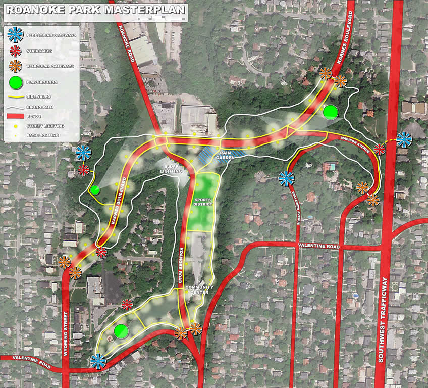
The Master Plan drawing has been updated as of April, 2011 with a few changes. Bluff lighting has been added and the Rain Garden is no longer shown atop the sand volleyball court. Strong community support has been expressed for keeping the sand volleyball court where it is.
ROANOKE PARK MASTER PLAN DESIGN PRINCIPLES
Connectivity
Connectivity to the park from the surrounding neighborhoods
- Sidewalks – connecting to neighborhoods
- Vehicular Gateways
- Pedestrian Gateways
- Staircases
Connectivity within the park
- Sidewalks – closing the loops
- Hiking Path – connecting with nature – educational opportunities
- Crosswalks – safe and secure road crossings
Roads
Karnes Boulevard
- Various Methods for traffic slowing
- Bike Paths
- Road Narrowing
- Road surface change at crosswalks (brick pavers)
Roanoke Boulevard
- Could be closed for community events
- Historic Street should be celebrated
Sports District
- Consolidation of “active” amenities to a central location
- Move tennis courts to allow for other uses (larger playground and rain garden)
- Utilize existing parking
- Develop organized activities with community center
Playgrounds
- Locations good – updates needed
- Water spray-mist/play area
Lighting
- Illuminate Bluffs in SW corner of Karnes and Roanoke
- Elegant street lighting along Karnes and Roanoke
- Path lighting (low level lighting – 42” and below)
Rain Garden
- Opportunity to showcase on-site water collection
- Water run-off control
View Corridors
- Quiet places to view the park from within the park
Signage
- Location with view informative vista features (bluff age, natural springs, seepage areas, etc)
- Educational
- Plants
- History